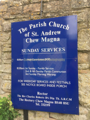
Chew Magna, Somerset
Photographed by James Derheim, European Focus Private Tours, on June 1, 2017
Chew Magna is a village and civil parish within the Chew Valley in the unitary authority of Bath and North East Somerset, in the ceremonial county of Somerset, England. The parish has a population of 1,149.[1]
To the south of the village is Chew Valley Lake. The village is on the B3130 road, about 10 miles (16 km) from Bristol, 15 miles (24 km) from Bath, 13 miles (21 km) from the city of Wells, and 6 miles (10 km) from Bristol Airport.
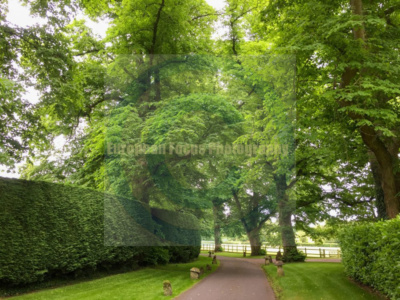
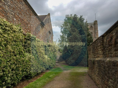
The village is close to the northern edge of the Mendip Hills (a designated Area of Outstanding Natural Beauty), and was designated a conservation area in 1978.[2] There are many listed buildings reflecting the history of the village. The River Chew flows through the village. Just outside the village is Chew Magna Reservoir: this small Bristol Water supply reservoir intercepts the Winford Brook.
There is one primary school, and an adjacent secondary school, several shops and small businesses, three churches, and three pubs serving the area. There is also a football pitch and children’s play area. The village frequently wins regional categories in the Calor Village of the Year competition, and is currently moving towards zero waste status, having been described as “probably the greenest parish in Britain”.[3]
History
Chew Magna has long been the largest village in the district, and can trace its importance back to Saxon times. It was a thriving woollen centre in the Middle Ages. In 1086, it had 108 households rendering £46 per year, most of its land being cultivated and having five mills, 29 cattle, 36 pigs, 448 sheep and 46 goats. It acquired market town and non-represented borough status. 22 of these households were serfs.[4][5]
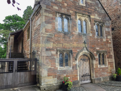
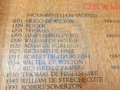
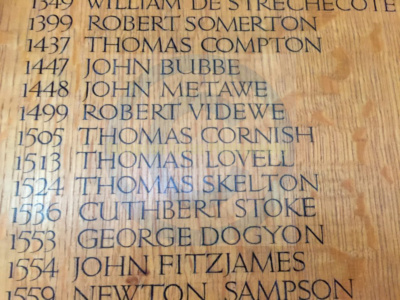
The manor of Chew was held by the Bishops of Bath and Wells from 1062 to 1548, and therefore was called Chew Episcopi or Bishop’s Chew. The bishops built a palace near the church of St Andrews, which was visited by Henry III in 1250.[6] During the king’s visit, a number of items were stolen including a ruby, gold coins and a ‘crested’ box, the latter being one of Henry’s personal effects. An inscription referring to this event was once visible in the main entrance to the manor, but has since been obscured by more modern repairs. Chew Court is a surviving part of the palace and has its adjacent well head also listed for its long heritage.[7]
According to Robinson its manors, lay and religious holdings formed an episcopal property held, as overlord, by Giso, the last Saxon bishop and the name Magna comes from the Latin meaning ‘the greater’.[8] This is supported by the Domesday Book which was made to specify the 1086 and the pre-conquest holder, in both instances given as the “Bishop of Wells”.[5] Hence its benefice was from the early medieval period converted from a rectory to a vicarage, with substantial tythings adjoining named Bishop Sutton, Knowle with Knighton Sutton, North Elm, and Stone. Furthermore, it had the living of Dundry annexed to it. By 1848 all tithes had been commuted and the sole impropriator is listed in 1848 of the great tithes as George Smyth.[9]
The parish was part of the hundred of Chew.[10]
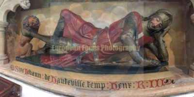
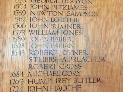
In the eastern corner of the south aisle of the church is a monument of the Baber family, who formerly had large possessions in the parish.[11] Inserted in a window of the aisle, is a wooden effigy, supposed to be of Sir John de Hautville, a Knight of Henry III’s, who owned the northeastern estate named Norton Hautville, now Norton Hawkfield: in the same directional corner of the church are monuments to the Strach(e)y family who lived at Sutton Court.[9] A c. 13th-century carved sundial is still visible, although eroded, to the right of the church’s door, and can be used to tell the time by carefully inserting a small stick to act as a gnomon. Midday is marked by a vertical line; post-meridian hours are to the right of this line.
After the Dissolution of the Monasteries
Since about 1600, the name changed to Chew Magna as this has been the most important of the several villages along the banks of the River Chew and reflecting the reduced wealth of the established church from the Dissolution of the Monasteries onwards.
Around 1700 the Lord of the Manor was Sir William Jones, the Attorney General of England[12] and in the 1820s it was the seat of Lord Lyttelton.[13] Until about 1880 the village had toll roads and a toll house to collect the fees.[14]
By 1848 the population was partly employed in coal mines in Bishop Sutton, and in the manufacture of stockings and of edge tools to a limited extent; formerly there was a factory for cloth.[9]
During the late 19th and 20th centuries the importance of the wool trade in the village declined and it became largely a dormitory area for the cities of Bristol and Bath, although it has continued to be the commercial centre of the valley throughout the decades, including the villages renowned Fairfield Nursery, managed by the Hiron’s.
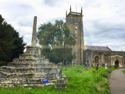
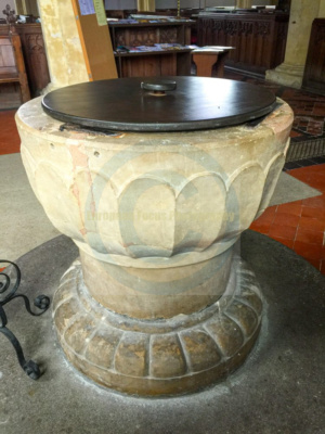
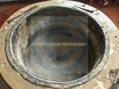
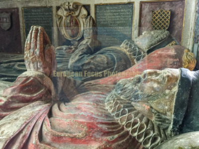
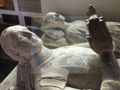
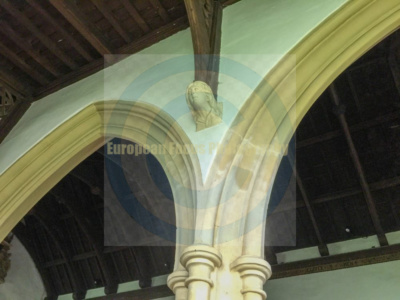
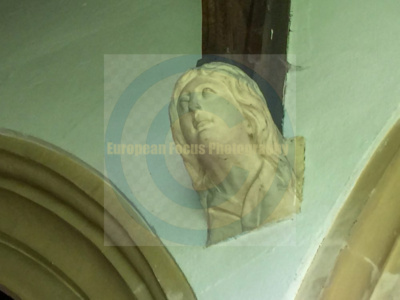
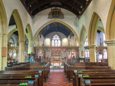
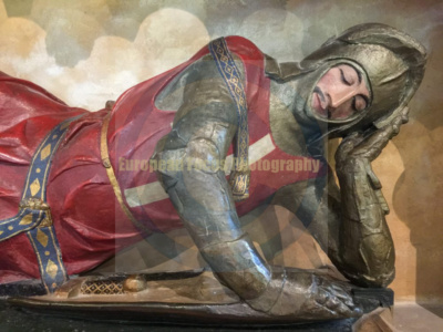
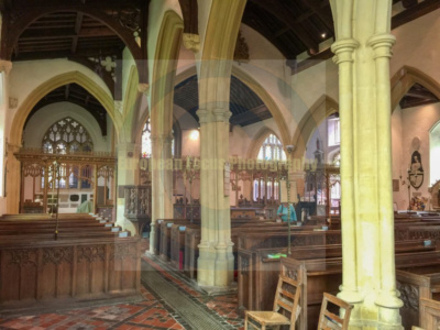
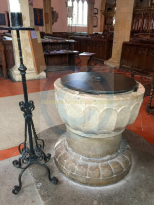
The Church of St. Andrew dates from the 12th century, with a large 15th-century pinnacled sandstone tower, a Norman font and a rood screen that is the full width of the church. In the church are several memorials to the Stracheys of Sutton Court, together with a wooden effigy of a Knight cross-legged and leaning on one elbow, in 15th-century armour, thought to be of Sir John de Hauteville or a descendant, and possibly transferred from a church at Norton Hautville before it was demolished.[25] Another effigy in the north chapel is of Sir John St Loe, who was over 7 feet (2 m) tall,[26] and his lady. The armoured figure is 7 feet 4 inches (2.24 m) long and his feet rest on a lion, while those of his lady rest on a dog. The tomb of Sir Edward Baber (1530–1578) son of Sir John Baber, is housed within the church alongside his wife Lady Catherine Leigh-Baber, daughter to Sir Thomas Leigh.[27]
The church was restored in 1860 and has a register commencing in 1562. The tower is about one hundred feet tall and was probably built about 1440.[28] There has been a clock on the tower since the early 1700s. There is a peal of eight bells in the tower (Tenor 28 cwt (3,136 pounds (1,422 kg) in C). The original five bells were re-cast by the celebrated Thomas Bilbie of Chew Stoke in 1735 to make a peal of six,[29] and in 1898 four of these were re-cast and two were repaired by Messrs. Mears and Stainbank of London to commemorate the Diamond Jubilee of Queen Victoria. Two additional bells, the gift of Brigadier Ommanney, were added in 1928 to complete the octave, which still contains two of the Bilbie bells. The present clock, installed in 1903, plays a verse of a hymn every four hours, at 8 am, noon, 4 and 8 pm, with a different hymn tune for every day of the week.[30] The church is a Grade I listed building.[31][32]
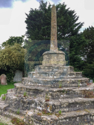
The churchyard contains several monuments which are Grade II listed buildings in their own right: the churchyard cross,[33] Edgell monument,[34] Fowler monument[35] and a group of three unidentified monuments.[36] In addition there is an early 19th-century limestone round-topped stone which bears the inscription to William Fowler “shot by an Highwayman on Dundry Hill 14 June 1814 aged 32 years”[37] and a Commonwealth war grave of a Royal Air Force officer of World War II.[38] Within the church are wooden plaques commemorating the nineteen people from the village who died in World War I[39] and seven from World War II,[40] and a bronze plaque to an individual soldier who died in 1917.